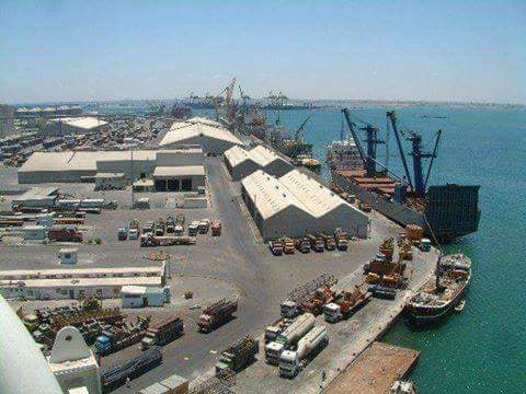
The Port of Aden is situated between the promontories of Aden (Jebel Shamsan, 553m) and Little Aden (Jebel Muzalqam, 374m). It is protected from the NE and SW monsoons by these hills and along the northern boundary by land, enabling it to operate without restriction all year. The harbour covers an area some 8 nm east-west and 3 nm north-south.
The port consists of the outer harbour, providing anchorage areas, the oil harbour at Little Aden on the west side of the bay, and the inner harbour to the east. These harbours are reached by a channel from the entrance mid-way between the promontories. The outer section of the channel has a depth of 15.0m. From the bifurcation point, a channel heading north west to the Little Aden oil harbour has a depth of 14.7m, leading to four berths for oil tankers at depths of between 11.6 and 15.85m, plus LPG and dry cargo berths and a RoRo berth, all at a depth of 11.0m.
The channel to the inner harbour, leading north east from the bifurcation point, has a least depth of 15.0m, leading to a turning area, depth 15.0m, diameter 700m, south of South of the Aden Container Terminal (ACT). The inner harbour has 10 alongside berths, plus 6 buoy and 3 bunkering (dolphin) berths with depths of between 6.7m and 14.0m for general cargo, livestock and bulk cargo ships. The smallest berths are at the Ma’alla Wharf, Berths Nos. 5 and 6, with depths of 6.7m, used by dhows, coastal livestock and cargo vessels. The largest is the Aden Gulf Terminal Berth No. 1 with a depth alongside of 14.0m.
On the north side of the inner harbour, the ACT provides 710m of quay, depth alongside 16.0m. The inner harbour is protected by a short breakwater at Ras Marbut, where the harbour control tower is situated. The Harbour Master's office is in the tower.
At the eastern end of the inner harbour and turning area, a short channel of depth 11.0m leads to the Ma'alla Terminal, with a RoRo berth depth 7.6m and 4 container/general/bulk berths of total length 750m, depth alongside 11.0m. At the eastern end of this terminal is the Home Trade Quay with two berths, 250m long, depth 6.7m. Facilities at the Ma’alla Terminal include a 7 hectare container storage yard, 50,000 MT capacity bulk silos and flour milling plant, together with bulk cement storage warehouse and cement silos, with bagging plants and bulk cement pumping systems. Within the inner harbour are also a fishing harbour and a ship repair yard.
Structural Port Dimensions
|
Item |
Dimension |
Measurement Unit |
|
Maximum Length of the Inner Harbour |
5.0 |
Km |
|
Maximum Length of the Outer Harbour |
10 |
Km |
|
Maximum Width of the Inner Harbour |
1.2 |
Km |
|
Maximum Width of the Outer Harbour |
7 |
Km |
|
Length of Approach Channel to Inner Harbour breakwater |
3.5 |
Nautical Miles |
|
Inner Harbour Approach Channel Depth |
15 |
Meters |
|
Total Port Area (approx.) |
131 |
Square Km |
|
Water area (approx.) |
129 |
Square Km |
|
Land Area (approx.) |
2 |
Square Km |
|
Total Container Yard Area (ACT) |
45 |
Hectares |
|
Total Open Storage Yards Area |
34 |
Hectares |
|
Total Enclosed Storage Area |
4.5 |
Hectares |
|
Oil Storage Tanks |
Numbers of Tanks in Various Locations serving the port and its bunkering operations |
|
Productive Port Measurements
|
Statement |
Capacity |
Quantity/Average |
|
Annual Bulk/General Cargo Handling Capacity |
5.5 |
Million MT/Year |
|
Annual Container Handling Capacity |
1,000,000 |
TEUs/Year |
|
Current Container Handling Throughput |
1,500 |
TEUs/Day |
|
Current Discharging and Loading Rate (General Cargo) |
11,900 |
MT/Day |
|
Office working Hours (for Operations 24/24) |
8-12 |
Hours/Day |


